Western Cairngorm Four Munro’s
Statistics
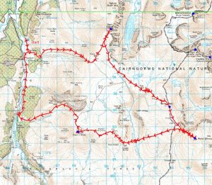
Area: Cairngorms
Munro’s: Beinn Bhrotain, Monadh Mor, Mullach Clach a’Bhlair, Sgor Gaoith
Date walked: 18/03/2012
Time taken: 8.9 hours
Distance: 37.4 km
Ascent: 1900m
The Route
Introduction
After not walking on Saturday due to a bad nights sleep on Friday night I was determined to get out on Sunday regardless. The weather forecast for the Cairngorms was simply smashing so with a big walk in mind I was off on my way to Glen Feshie and duly arrived at the car parking area 1km North of Auchlean at about 0720hrs. The sun was shining but in the valley it was a cold -7 (as recorded by the car). There was a frost everywhere and unusually I had to don my jacket for the start of the walk. There were a couple of cars covered in ice so must have been here overnight. I spoke to one walker in the car park. He was walking to the Fhiddler from here so had a good 40km of walking to do today albeit mostly flat. Still a big walk which would take the best part of the day.
The Walk
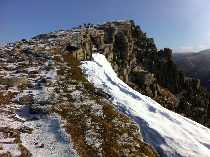
I set off down the track to the farm at Auchlean. The sun was shining in spectacular fashion on the farm buildings whilst I was in the cold shade on the path. There is a small sign here indicating the track into the hillside which disappears into the forest. The path meanders through the forest and onto the open hillside traversing the hills as it climbs adjacent to the Alt Fhearnagan. There is an upper path and a lower path and they both climb the hillside to the small cairn below Carn Ban Mor indicating the split in the path for Mullach Clach a’Bhlair, Sgor Gaoith and indeed Monadh Mor and Beinn Bhrotain for those more adventurous on the day. I was heading for Sgor Gaoith first today so I took the left fork gently climbing up Carn Ban Mor. I met my first walker of the day here. A young lad. He had bivied on Sgor Gaoith and woke up covered in ice although he was nice and warm inside his bivvy. Without further ado I was on the summit of Sgor gaoith and I was flying at this point. I had worked hard uphill and arrived at the summit just under 1hr and 40 minutes from the car. Not bad for a climb of 800m over a distance of 8km. A good measure of my fitness but I was to pay for my exuberance later on hahaha. The sun was shining but there was a very cold breeze blowing in from the west. It was not very strong at this point but it was to get stronger as the day progressed.
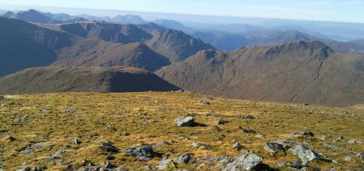
I now head back the way I had come for 1km before veering South east heading for Tom Dubh 3.5km in the distance. This is a very boggy area and although losing a couple of hundred meters in height it’s so gentle there are loads of peat hags and waterways. As luck would have it the extremely cold night that had just passed ensured there was a good crisp covering of ice on top of pretty frozen ground and it was just a case of plotting your route visually ahead and watching your steps. I can clearly see the high plateau of the Cairngorms a few km’s to the east, hosting Cairn Tool, The Angels peak, Braeriach and the Devils point. Cairn Toul looks awesome from here just like a peak from a spaghetti western out in Nevada somewhere. I soon arrive at Tom Dubh. There is a good shelter cairn here but the Westerly wind is cold and getting stronger so short of lying down to get out of the wind I decide to head down to the Allt Luineag burn, hidden in a deep cleft in the valley, before I stop for a bite to eat. So after crossing the burn without mishap I settle down for my first bite of the day. I had with me some bananas, nuts and trail mix, chocolate, and flapjacks, I normally take some pasta on these longer walks but instead I took some cheese wrapped in ham. Now this was delicious but unfortunately I think now it was the wrong choice of food. So after a good feast I was on my way again. Simply continue in a SE direction over the spot height of 974 and onto the lower slopes of Monadh Mor. A short climb later and I am on the rocky summit of Munro number two. Its slightly in the clouds so the views are a bit restricted, however I can clearly see Beinn Bhrotain and it looks like one huge lump of a mountain and its only about 3km away.
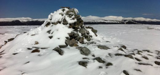
So I now head South over Leac Ghorm and descend to the Beallach. Beinn Bhrotains boulder slope is glistening silver in the sunshine. It’s just under 200m of climb over 1km to reach the summit but it is one huge boulder field and I am feeling a bit tired. However with head down and watching each footstep I soon reach the summit. There is a trig point here and a separate shelter cairn so I take shelter in the shelter cairn and have some more food. I have bananas and more flapjack but I know my body is looking for come pasta which I don’t have. Not to worry, its only 20km and one Munro back to the car hahaha.
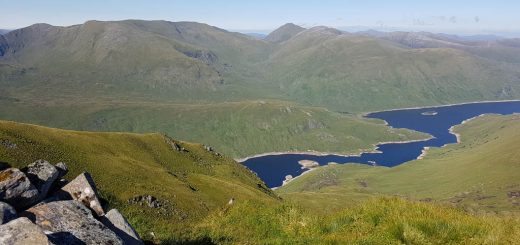
So after a good rest I descend back to the Beallach. This was very painful on the knees and I was just glad to get down from the boulders. I met a couple of walkers that had come in from Glen Feshie to do these two munros and they were making good progress. From here Mullach Clach a’Bhlair is pretty much directly West but due to the snow and the Cornices around the shoulder of Leac Ghorm I have to ascend 100m or so back up the track before heading West across and down the hillside. The descent is fairly good underfoot with the odd peat hag here and there and after 3km I reach the river Eidart. It was flowing quite strongly but was not in spate and I found a suitable crossing. It’s now a 450m ascent up to the spot height at 974. This was quite steep in places and I was running low on energy. I was glad to eventually reach the plateau and join the Landrover track all the way to just below Mullach Clach a’Bhlair. A quick gentle ascent and I was on my final Munro summit of the day. I met a walker who had cycled in from Linn of Dee to Geldie Lodge and then walked up here. Good effort. Another Banana and some Jelly babies and I am on my way again.
I pick up the Landrover track as it heads down the hillside. I pass the turn off which would take you over Meall nan Sleac and down the hillside, preferring instead to follow the Landrover track all the way down to the bridge at Carnachuin. This adds a couple of km to the walk but with my knees feeling the pace and low on energy I thought I might as well take what I considered to be the easy option. Bridge what bridge hahaha. The bridge has been washed away. Some of it remains and there is a sign warning you that you cross on the bridge at your peril hahaha. So now instead of an easy walk along the road I have a further 4.5km of forest track with another river crossing culminating in the final 1.5km walk along the road to the car. It was good to get back to the car. That was a cold long day in the hills but a good one.