A round of the Tarf Munros from Blair Atholl

Statistics
Area: Glen Tromie to Glen Tilt
Munro’s: An Sgarsoch, Beinn Dearg (Blair Atholl), Carn a’Chlamain, Carn an Fhidhleir (Carn Ealar)
Date walked: 29/04/2012
Time taken: 11.75 hours
Distance: 50.2 km
Ascent: 2400m
The Route
Introduction
Now over the last couple of years I had been looking at doing the complete round from Blair Athol but every time I looked at it I had to look in the mirror to make sure a complete idiot wasn’t looking back hahah. I did wonder on occasion. So this year I have picked off Beinn Dearg and Carn a Chlamain as singles (Chlamain with the Corbett), both big walks on their own, and now I had An Sgarsoch and Carn Ealar to do. I was thinking I could cycle in from Linn of Dee and bag them both. Now I was looking at maybe doing that on Sunday past (yesterday) but with all the rain recently I could not be sure of issues with crossing the burns (rivers) and it would be an awful shame to cycle all that way in and have to turn round without bagging anything. I called Danny and asked his opinion. He said “do them from Blair Atholl. Walk in walk out. No probs”. Well he is pretty straight to the point sometimes and the decision was made.
So early to bed 2300 and up at 0330. Good breakfast and check kit. Because I am going into a pretty remote place the basic kit list was as follows. (actually I pretty much carry this lot anyway with the addition of ice axe and crampons but they would not be needed on this walk)
In my backpack
Sleeping bag, bivvy bag, spare socks, spare fleece, first aid kit, spare laces, puri tabs (filled up from the burn without using them), GPS phone and spare batteries, Headtorch and spare batteries, 2 litres of water, 1 litre of energy drink, energy bars, bananas, flapjack, chocolate, mirror, whistle, walking poles (didn’t use them), micro spikes, waterproof trousers. Jacket hung over pack
Wearing
Underwear, trousers, two pair of socks, boots, gaitors, base layer vest and one top.
The Walk
So, I arrived at Bridge of Tilt car park at 0530 and was on my way just after 0540. Its -3 at the car park and feeling quite cold but I was going to walk in at a good pace so knew I would warm up soon. So out the car park turn left and along the road bending right and down to and over the cross roads following the track into the forest. Its pretty straight forward. Stay on the main track, do not go right or left and I soon arrive at the gate. Through the gate and into open country. Its cold with ice on the grass but the sun is rising. It will warm up at some stage I hope.
So after 10km of meandering past the cairn and onwards over a burn and up and down I arrive at Allt Sheicheachan bothy. A quick look inside and its looking pristine. A note in the diary says the doorman was here yesterday. I leave a note and exit, crossing the burn, and heading North East up the track. After a couple of km’s the track turns left and heads up the hillside. Quite a contrast to when I was last here and the track was covered in snow. So I continue on the track all the way past the cairn below the summit and arrive at Beinn Dearg summit at 0835.
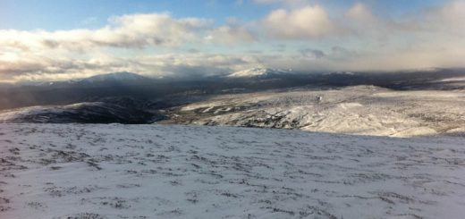
The views were extensive with a huge snow cap over the high Cairngorms and some snow on the two Geldie Munro’s. I had checked my gps during the walk in and was not getting a signal. Occasionally I would have two satellites but you need three for triangulation so I wonder if the military have blocked the signal this morning. The weather was bright with the sun coming out over a clear sky so navigation would not be a problem. However it was cold. My hands started to freeze in the cold wind just taking a few photos so on with the jacket and on my way.
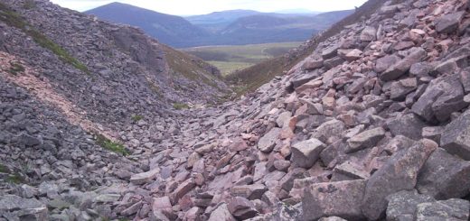
Its now on to the Corbett Beinn Bhreach. Its simply 3km North and then 1km North East to the summit crossing upper Tarf water on the way. The route is pathless downhill over deep heather to the peat bogs of Caisteal a Choire. The bogs are about 1km wide and it was great to have the ground partially frozen. This would be a nightmare in a wet summer. It was still energy sapping jumping from tuft to tuft but I had plenty energy to spare hahaha. I was soon over the bogs and ascending the heather clad slope up to the Corbett summit. Again fantastic views. The cold biting wind is still blowing from the North East so no time or shelter to stop and I continue on my way.
I continue North East for 3km to the Bealach below Meall Tionall and then head East for the last 1.5km to the summit of Carn Ealer heading North for the last 100m or so to the cairn. On the way I stopped for lunch at the Bealach below Cnap a Choire Chreagaich where I could find some shelter out of the wind. Again there were peat bogs on the Bealach’s below all the hills which would be tough going in the wet. As I ascended Carn Ealer there were large sheets of snow to cross. Some firm on top and others where the crust would break and your leg would go through. Just enough to drain more energy than was required on each step hahaha but we have all had those conditions.
I was thinking at one point I should have brought my ice axe but I could just about cross the snow without slipping so it would be ok. The summit is closer to the high Cairngorms and they look amasing with the snow on top. The photos don’t do them justice. Excellent views in the sunshine but the wind is actually getting stronger now and its bitingly cold. Footprints in the snow of a previous visitor, probably Saturday, show the way South then South East for 2km past the 906 spot hieght and down to the Bealach. The huge bulk of An Sgarsoch’s West ridge rising up in front of me with again no obvious tracks. Itsbasically a direct ascent for just over 1km to the summit of An Sgarsoch. just 2m shorter than Beinn Dearg so its all down hill from here metaphorically speaking hahaha. Its 1225 so its been a good round so far. Did I say it was cold? Well its still cold so I continue on my way.
I head South for 2km over the spot height of 967 and down to Sron na Macranaich. A decision has to be made here. Its a 3km descent to Tarf Bothy and then climb Meall Tionall and Carn a Chlamain and descend to get back to Old Bridge of tilt. Alternatively I could head South West for 3km, cross tarf Water and continue on the track that joins the estate road 3km later at the river Tilt, 2km South West of the Bedford Memorial Bridge and Falls of Tarf. Then follow the road out of the Glen.
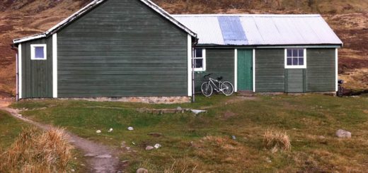
There is really only one choice for me and that is Tarf Bothy and Carn a Chlamain. So I head descending into the valley across the peat bogs and Tarf Water. Its about knee deep in places and I run across getting soaked in the process. Half a km further on I run across it again because the bank sort of disappears. I cross again just before getting to Tarf Bothy. Ah, a nice peaceful rest before the final walk out. I check the rooms out and it looks quite cosy. I still have 20km to go so I eat the rest of my energy bars and drink the rest of my electrolite drink and basically eat the rest of my meager rations. I feel ok though. No worries. Knees have been good. I have not seen anyone on these hills today and both bothies were empty.
So I leave the Tarf Hotel and head South West for 1.5km to the summit of Meall Tionall. This is a steep ascent and certainly gets to the parts other ascents don’t reach especially after my walk so far. Then I head South up Conlach Beag and finally find myself on the pointy summit of Carn a Chlamain for the second time this year. Approximately 9 hours 40 minutes to get here. The wind has increased in strength. For those tougher than me you can add the second Corbett, but since I done that a few weeks ago I am giving it a miss hahaha.
One last look at the excellent views and I am heading down the hillside joining the Landover track for the route out. After a couple of km’s the Landrover track bends in a horseshoe and there is a small track continuing South West down the hillside which is the way forward. This takes me down to Soldiers Bridge and the road out of Glen Tilt. Its a beautiful evening and I take my jacket of for the first time since Beinn Dearg. Its now jelly baby heaven as I walk the 8km out of the Glen past Marble Lodge, Monitoring Station, the cottage and some amasing rock structures in the river to cross Gilberts Bridge.
After crossing the bridge there is a sign saying the road is closed due to full bore firing on the range, so back across the bridge and follow the road back out the Glen, dropping into the canyon for the last couple of hundred meters to the van. What an awesome day.