Character building on Beinn Dearg
Statistics
Area: Glen Tromie to Glen Tilt
Munro’s: Beinn Dearg (Blair Atholl)
Date walked: 22/01/2012
Time taken: 5.54 hours
Distance: 30.1 km
Ascent: 1078m
Introduction
Ok, this weekend was set to be a windy one to say the least. Saturdays forecast was for winds of 70mph gusting to 100mph on most Munro tops so it was not really a good idea to be out and about Munro bagging. Sundays forecast was to be better with a wind of 50mph. Mind you that did not stop Andrew from bagging Beinn Dearg and Mackenzie and Kevin attempting to walk in Kintail in the horrible weather on Saturday. My plan was to walk Sunday although I was not overly enthusiastic with the strong winds forecast. So I woke up at 0530 and the wind was blowing a hoolie outside at sea level hahaha so I was having to rethink whether walking was a good idea but as luck would have it the wind dropped by 0615 and I was back on track. A hearty porridge breakfast and I was on the way at 0700.
The Walk
It only took an hour to get to the car park at Glen Tilt. It’s quite a big car park just inside the forest with a good walk route guide on display. A quick change into walking boots I was walking up the road at 0812.
So out the car park and turn left walking along the road for a couple of hundred meters and then take the right hand fork in the road. 500m later I cross the cross roads and onto the Landrover track into the forest. the track goes uphill and bends for about 1km. There is now a fork in the track. One fork, which I took goes down to the bridge by the river. There is a post here with a black arrow on it indicating the direction to go if you are walking the Banvie trail. The Banvie trail is not what I am walking today and I do not cross the bridge but take the right hand fork taking me back up to the Landrover trail which I should have stayed on and in fact I do stay on the Landrover trail when I return. After another 800m there is a post with a black arrow again indicating the Banvie trail which forks left here but I continue on the Landrover track for another 50m or so to the gate at the end of the forest and continue on my way. The track is icy but there is not much snow but this soon changes so there must have been a good snow fall last night. A further 1.2km later and I arrive at a large cairn. Just before I reach Cairn there is a small corrie where there has been a landslide into the burn. Looks interesting. So past the cairn and keep left.Its now a long 5.5km slog to the Allt Sheicheachan bothy. The snow is getting deeper on the path as I progress but its not a problem. The only marks in the snow are those of a fox I think. It walks the path almost to the bothy. I do see the occasional footprints of a hare crossing the path on occasion. There is a large herd of deer which scatter as soon as they sense me so I only get fleeting glimpses of them and eventually I arrive at the bothy. I stop here for refreshments. It’s quite tidy inside the bothy. There is a good set of fire fighting kit and a small bottle of whisky is on the window. I know what your thinking but no I left it alone. There is a message in the guest book saying the door doesn’t shut properly so I should report that to the MBA.
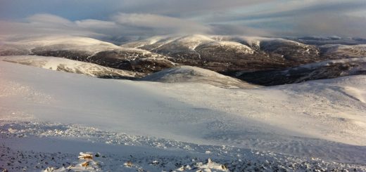
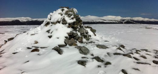
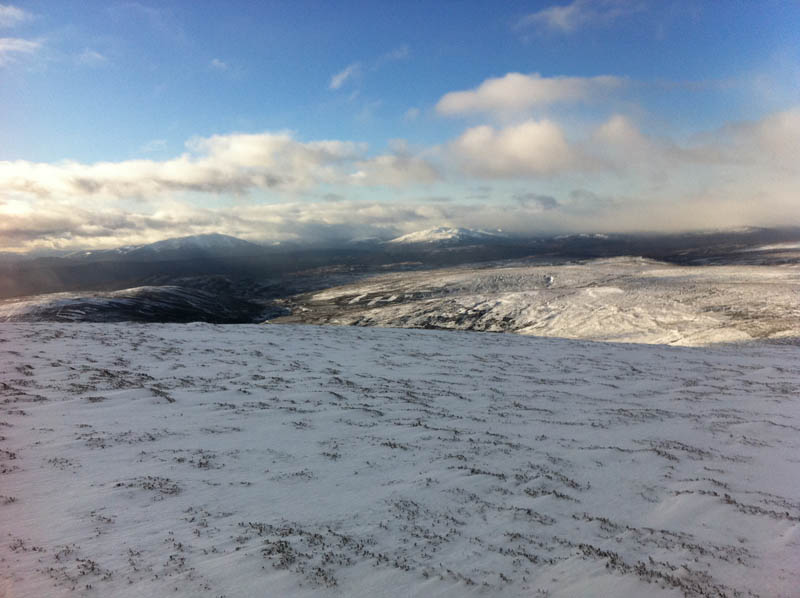
I am soon on my way, cross the burn and take the path along the hillside. The path is easy enough to follow and after 2.2km it bends back on itself as it starts to climb the hillside. I follow this for about 200m but its pretty deep with snow drift so I just head North up the hillside to the Meall Dubh nan Dearcag. I stop at 800m to take a couple of photos. Looking back across the burn I can clearly see a good path, which is an alternative walk in walk out path, heading over the hillside back to glen Tilt. Looking north Beinn Dearg summit is in some pretty dark clag and the wind is picking up now. It’s now only 2km to the summit pretty much North slightly East past the large cairn on the Munro top and over the icy large boulders near the summit. With the ice and snow this is pretty tricky. It would be easy to have a fall. There were also a couple of large ice sheets to cross after the Munro top but they really presented no problems. There is a large square trig point inside the shelter cairn but the wind was pretty strong and it was really cold so I was not hanging around. I immediately set of back towards the Munro top. The clag was now like a whiteout briefly and it would be so easy to become disorientated. I can’t find my footfall so I head of at a run down the hillside. Looking at my gps it almost follows the track up so what happened to my footsteps in the snow hahaha. I find them again below the 800m point and I am now happy to bound down the slope. Mind you the snow drifts make that a little precarious at times. At around 1km from the bothy I meet another walk highland member. I think its Smudger so good to meet you sir. Smudger was with his son Daniel I think so I hope they got on ok today. Just behind them was a group of four from Dumfries and I had a brief chat with them also. I was soon back in the bothy having another well earned rest and replenishment. I had decided to come back to the bothy for shelter and a rest rather than use the alternate path back to Glen tilt. Its now just a matter of the loooooong walk/jog out and I am back at the car at 1407. That was tough. My first long walk of the year. There was not any great ascent to climb and the slopes are not steep but it was a tiring walk.
On checking my phone the summit shot is not there. I thought I took one but in the conditions looks like I didn’t. Ow well just have to go back hahaha.