Ben Starav Round
Statistics
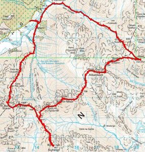
Area: Glen Etive to Glen Lochy
Munros: Ben Starav, Beinn nan Aighenan, Glas Bheinn Mhor, Stob Coir an Albannaich, Meall nan Eun
Date walked 07/11/10
Time Taken 8 hours
Distance 26km
Ascent 2500m
The Route
Introduction
With the winter nights drawing in and the hours of daylight diminishing I realised that I probably had one last chance to do the Ben Starav round of Munro’s this year and that would be this weekend. In addition to my thoughts MWIS had forecast excellent sunny weather, which has been like gold dust this year, albeit accompanied by sub-zero temperatures and it looked like a plan was coming together. However, my employer had other ideas and decided that I needed to drive to Hartlepool and Newcastle to do some work on the Saturday and as usual I did not receive these instructions until the Friday afternoon.
So on Saturday night, after an early start and 8 hours of driving behind me, Ben Starav was firmly stored in the back of my mind for another year. I had been invited to a party so any thoughts of walking on the Sunday were also on hold due to my expected consumption of alcohol being the good social drinker that I am lol, and anyway after my early start today and long drive the idea of getting up at 0400 and driving in below zero temperatures was not very appealing. The trouble with the list of Munro’s is that it gets its hooks into you and doesn’t let go. The party was in full swing when I arrived, with good music and food but as the talk worked its way around to my Munro progress Ben Starav popped back up and I just knew I had to go. So after an one hour of partying and only one beer consumed I had made my mind up to walk on Sunday and I was off home to bed.
After a short restless sleep I was up at 04:00 and after a quick breakfast with strong coffee I was on the road by 04:30. The temperature in Fife was about 3 degrees but as I approached Callendar the temp had dropped to zero degrees dropping to -2 degrees at Tyndrum. The gritters were out in force so that gave me some confidence that I would be able to stay on the road and not after all end up in a ditch somewhere. As I was passing the Kings House Hotel on the A82 I had to come to a stop as a magnificent Fox was standing in the road only ten feet in front of the car. On the road there was a small furry animal, a mouse or vole or something. The Fox looked up at the car, then scoffed the little creature in one gulp then casually walked off into the long grass at the side of the road. Shame I couldn’t get a picture but as is usual in these circumstances the action is over before I get ready to take the photo lol. As I drove along the Glen Etive single track road the temperature dropped to -4 degrees and not long before I arrived at the start of the walk a herd of deer on the road once again brought me to a halt. The deer quickly left the road and a minute or so later I was parked up at the side of the road near Coileitir.
The Walk
It was now 06:50 and it was still dark. I changed into my walking boots and by the time I was ready to start walking daylight was appearing on the horizon. I crossed the road and climbed over the gate taking the path down to the bridge which crosses the river Etive and then bends right heading to Coileitir. I see one of the stags that I saw earlier, now on the hillside, and I take a photo before skating across the bridge because it has a layer of surface water on it that has turned to ice.
The path on the map continues from the bridge along the river for a further 700m and then bends to join a bridge over the Allt Mheuran, however after about 100m there is a fenced off area with a locked gate blocking the path. There are signs of footfall going south following the line of the enclosure so that’s the way I go. The path is extremely boggy but is also almost frozen so my boots don’t get too wet. After another 100m there is a stile but I decide to continue past it making a beeline for the burn in the direction of the Ben Starav ridgeline. When I get to the burn it is almost in spate with a huge waterfall which I can’t cross so I have to follow the burn South for 10m or so until I find a suitable crossing point. It might have been prudent to go downstream to the bridge as It is still a bit precarious and I have to jump across a couple of boulders but I am soon safely on the other side following the path into the Glen.
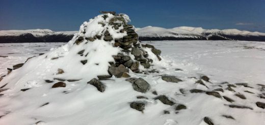
After a couple of hundred metres I take the right fork leading up the steep climb onto the Ben Starav ridge. It is cold but there is no wind, no cloud and the sun is coming out. It’s now about an 850m climb over 2.3km approximately to the summit of Ben Starav. It’s a fairly steep but steady climb all the way to the summit but I am working hard and I make good progress and after a short while I am at the summit of the first Munro. Ben Starav doesn’t have a cairn as such, it just comes to a point. There is thick ice on the vegetation and the views are incredible but it is cold so after some quick refreshments I head off on my way.
The route goes around to Ben Staravs second top and along a nice ridgeline to Stob Coire Dheirg where it then heads East down to the beallach at 766m on a good path. However, it’s only now that I realise that paths on the hills tend to be a different colour to the surrounding terrain making them easier to follow. I mention this because the frost makes the ground all the same colour and the path seems to disappear now and again throughout the day. My next Munro is Beinn nan Aighenan, so I follow the path dropping to the beallach at 600m. There is an obvious path that heads more directly down the valley which I think would take me all the way down to Glen Kinglass which is not where I want to go. So care needs to be taken to ensure the correct route is followed and I take the path traversing the hillside instead.
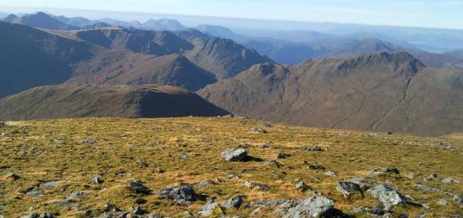
I am soon at the beallach and it’ nows a simple 1km climb ascending 350m to the summit. The views are excellent all round but I don’t hang about and head back down to the beallach. As I descended I was looking for a path heading up Meall nan Tri Tighearnan. I could clearly see there was nothing to be gained with a drop and direct ascent up to Glas Bheinn Mhor so heading up to the minor top was the best option.
However there did not seem to be a path so once I got to the 700m contour I decided just to head straight up the hillside avoiding the crags as I go and in no time I was on a good path heading to the third summit.
The wind had increased quite a bit now and it is really cold. I could see huge cloud banks appearing above the southern Munros and wondered if I would get round before they arrived. When I arrived on the summit of Glas Bheinn Mhor I got my water bottle out to have a drink and the water was half frozen. I store the water bottle in the outside netting on the rucksack so the current low ambient temperature in addition to the wind chill factor has turned most of my water to ice.
I need fluid though so I take a big drink and I get brain freeze just like when you eat an ice cream to quickly lol. It’s not good for two reasons. One I can’t drink enough fluid and because it is too cold my body will be burning valuable energy warming it up. However I don’t have much choice at this point and I have just got to push on.
I now head East down the ridgeline for 700m and then North East for 400m to the Bealach at 728m. There is an obvious path heading down the valley for those that are doing the two or three Munros but looking at the map there are a hundred burns to cross so it would not be a route of my choosing. There does not appear to be any path going up the opposite hillside heading in the direction of Stob Coir an Albannaich so I just head North West for 130m up the steep slope to the ridgeline. Of Sron Nan Cabar. Once there it’s easy enough to pick a semi circular route around the Coire and onto the summit. You don’t want to go too deep into the coire because it is an undulating boggy area full of rivulets and burns but I stop here at one of the burns and fill my bottle with fresh running water from under the ice. I also take a brain numbing drink lol.
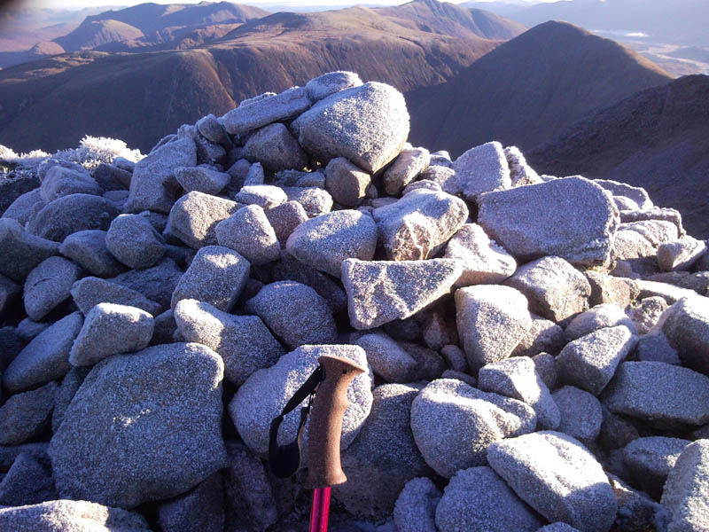
I had started to get cramp in my arms and legs on the ascent to this Munro probably due to lack of fluid so I force myself to have a good drink and eat lots of jelly babies for energy. Looking above me the cloud had arrived, the wind was fierce and cold and the summit was in clag but as the song goes “the only way is up”. So onwards I go and soon arrive at the summit. I found it to be quite a strange summit cairn, in fact it’s just a couple of rocks really.
I now continue west across the cold summit and descend for about 120m over 0.6km. I am looking for a reasonable descent down to the Northern Bealach and as luck would have it there is a small cairn marking the descent. The descent is quite steep with a slight path heading down which I lose but I am soon at the beallach at 754m. The path goes up the hillside towards Meall Tarsuinn but I then choose to traverse across the hillside to avoid the small summit. I regain the path and head east to the Beallach and then up the short climb to the summit of Meall nan Eun. I take it easy on this the final ascent due to cramp issues and I am soon on my final summit.
There are no shelter cairns on any of these hills and I am still in the clag so nothing for it now but to head home.
It’s a featureless hillside and it’s easy to become disorientated in the clag but with my trusty map and compass (gps), I am soon heading in the right direction. I don’t see any path so I basically have a 7km walk North West back to the car descending the frozen steep craggy hillside of Coirean Riabhach before finding some sort of path back to the landrover track at Glenceitlein. I then cross the bridge and follow the landrover track the 1.5km back to the car.
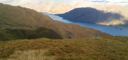
The 4km view down Glen Ceitlein from the top of Coirean Riabhacr below the clag with Beinn Chaorach on the left and Stob Dubh on the right is awesome. It also looks a long long way to walk lol.
I am so happy to have completed this walk today and with the fantastic weather, albeit cold, it was a good decision. This completes an excellent year of hill walking for 2010.