Loch Mullardoch Circuit (12 Munros in a day)

Statistics
Area: Cannich to Loch Duich and Killilan to Inverness
Munros: An Riabhachan, An Socach, An Socach, Beinn Fhionnlaidh, Carn Eige, Carn nan Gobhar, Mam Sodhail, Mullach nan Dheiragain, Sgurr na Lapaich, Sgurr nan Ceathreamhnan, Toll Creagach, Tom a’Choinich
Date walked: 24/07/2017
Time taken: 20.5 hours
Distance: 58 km
Ascent: 4800m
The Route

Introduction
Well with a weather window coming in for Sunshine on Monday 24th July 2017, North of the Great Glen, it was time to complete the Mullardoch Challenge. This would be a huge walk of 58km ascending just short of 5000m and covering the 12 Munros around Lock Mullardoch. I had attempted this walk before in May 2012 but unfortunately bailed after getting mild heat exhaustion after only 24km. So, five years later on and now 57 years old its time to revisit this round. Some would say I am mad to try it, others would say you have nothing to prove, but sometimes these Munros get under your skin and its just extremely hard to resist. I am fitter and stronger than I was then and probably more determined than ever so its on.
The Walk
Ok with preparation done I am heading up to Cannich on Sunday 23rd July and arrive at the pub at 1920. I stop for a coffee because its the last hot drink I will have for 36 hours before heading into the grassy area below Mullardoch Dam. There are very few midges around but I don’t hang about and in no time I am safely in my tent with all my gear preparing to hopefully catch 4 hours sleep. Its now 2100 and my alarm is set for 0100. As is the norm with these kind of events just as I was nodding off a car draws up and two guys set up there own camp. They were not overly noisy and within half an hour they were dead quiet. However its now 2215 and I am awake. Ok I reset the alarm for 0130 just to give me a little more shut eye and drift off to sleep. At 2340 another car draws up with music blaring from its open window. This inconsiderate individual hangs about for 5 minutes then heads off up to the dam. So basically 0120 arrives and I really do not think i have slept more than an hour so I decide to make a move. After a banana and small pork pie for breakfast washed down with a 500ml bottle of Lucazade sport I am out the tent and on my way. I left a note in the car window explaining that I would be back by 2200 and headed off up the road heading into the Lochside. I had also told Scraggles and Danny my plans and would text them as I progressed.
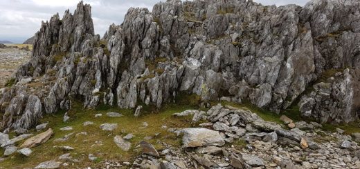
There is a new wide flat track into the glen which makes the walk in quite enjoyable. After about 1.5km the track heads North and climbs gently as it ascends the glen along the Alt Mullardoch. After approximately 2km the large track comes to an end and in the dark there doesn’t appear to be any tracks continuing into the hillside. However its now just a case of heading over the heather in a North West direction for another 2km to the Beallach and then head just South of West ascending the final 1km to the summit of Carn nan Gobhar. (I did find a small track up the hillside which makes for slightly easier walking.) The first summit was an easy ascent of 770m and it is still in the darkness, but the sun is starting to rise behind me far away to the East. So with 1hr 35 mins gone I continue on my way. So a drop down to the Beallach above Loch Tuill Bhearnach and then 350m of ascent up to Sgurr na Lapaich over 2.2km. Its a nice ridge and takes me no time at all arriving at the summit at 0432. I can see some inversions behind me and cant wait to see the views when the sun comes out in full. I am moving quite well and arive at the summit of An Riabhachan in just over an hour at 0533 a distance of 3.2km with an ascent of 300m. The terrain is easy walking on this north ridge. Now on to the 4th Munro on the North ridge. Again its easy walking this 4km climbing 300m and i am on the summit of An Socach at 0648.
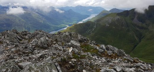
The sun is out now but not yet hot enough to cause me any worry. The views are incredible. There are clouds loitering in the glens in all directions and Loch Mullardoch has a cover of cloud over the entire Loch, amassing. This is why I love the Mountains of Scotland. I have drunk nearly 2 litres of fluid and eaten a couple of mini pork pies, a chocolate bar and one energy gell. I feel good. I have a 10 minute rest and head of around the ridge. After 300m I head directly South West down the hillside. I am looking for a burn (small stream) in order to replenish my water supplies. I can fill my bottles from the Gobh-Alltan in the glen but I would rather fill them from higher up the mountainside and after descending 250m over 1km I find the perfect spot. So after a good drink I now have 2.5 liters of fluid, some of it with added electrolyte powder, to see me until the next water stop in 20km time below Mam Sodhail. I continue downhill contouring round Meall Shuas then heading south at a pace to join the track down to the river Gobh Alltan arriving there at 0815. That descent was over 5km dropping 800m approximately. I have been here before hahaha.
I am awful sweaty at this point. Ok maybe thats something you do not want to hear but I am wearing a Strathearn Harriers long sleeve running top and my trousers are semi waterproof. With the effort coming quickly down the hillside I am overheating somewhat. The eletrolyte drink will help but I decide to take my top off and go “Tapps aff” as wee Scottish like tae say. Its always a dificult decision when heading into the hillside on what kind of top to wear. Most if not all the walking tops you buy are plastic (polyethylenthe, polyester whatever). They make you sweat. Now they tell you that they are wicking and take the moisture out to the other layers if you have any on. I am not so sure it works for me. I tend to find that these plastic tops make me sweat. Thats not a problem when you go fast and hard over a smaller number of munros but on a round like this you do not want to lose to many body salts. Its also probaly not too much of a problem if you are a gentle walker and the tops probably do what they say but when your mad like me…its nae gid. 🙂 The alternative is a cotton top. Its great to feel a soft cotton top against your skin in the hills but you have to be careful because they hold the sweat and then can get very cold if the temperature drops. So I compromise. I wear the poly top for the hard bits and then change to a cotton top when I am slowing down a bit. That means I will be putting on my cotton top after the next Munro, Mullach na Dheiragain. The ascent to this Munro, although not the steepest by any means, wil most likely be psychologically the hardest part of this walk. Its just under 700m of ascent over 4km.
So I cross the burn and take the track for 500m along the Gobh-alltan then head directly up the hillside in a South West direction. I find a good track in no time and gently push my body uphill. The views are opening out as I ascend in the sunshine and I can now see Loch Mullardoch below the cloud. I go directly up Creag a Choir Aird and then head SSE up to Mullach Sithidh and onto Mullach na Dheiragain summit. Its now 1004. That was tough. I stop for a good 20 minutes and eat, drink and put my cotton top on. Its now 4km ascending 350m to the summit of Sgurr nan Ceathreamhnan with a small ascent and descent over the Carn na Con Dhu in between.
1154 on the summit of Sgurr nan Ceathreamhnan number 6 on the round. So its halfway in Munro numbers, at 28km its halway in distance but the important point is I have ascended 3000 vertical meters and there is only 1800 or so meters to ascend. Now normally an 1800m ascent would be a reasonable walk but in the context of this round its on the home straight hahaha. The views are superb. I had met a nice chap below the summit. He was out running. He had tried to do the round yesterday but ran out of water so done 8 of the 12 and was back today to do the final 4. The importance of planning on this walk is crucial for success. Plan the water stops and take chlorine tablets in case you need to fill up from a static water source.
Ok so after a short stop I continue on my way. An Socach (another one) is next. Its a nice 300m descent and then a 130m ascent over 3.8km to reach this summit. Just like a gentle stroll really. Next on the round is Mam Sodhail. You drop down to 715m then climb up to this summit at 1181m over a distance of 4.5km. There is a nice path that traverses up the hillside bypassing the Munro top at 1108m. Its halfway around this bypass path that I find the small burn (stream. I was hoping it was still here) from which I could replenish my now empty water bottles. I still have 20km to go so I replenish all three and fill one with electrolyte whilst drinking my fill at the same time. Its now very hot. As the path comes to an end I just take a eye bearing on Mam Sodhail and cross the terrain ascending as I go. I arrive at the summit at 1504. The views are excellent all round.
Carne Eige seems like a stone throw away around the corrie but I need to bypass it and head to the Beallach Beag below Beinn Fhionnlaidh my next Munro. So crossing the lower slopes of Carn Eige over a number of boulder fields onto the Beallach and up to the summit of Beinn Fhionnlaidh only takes me just over the hour a distance of 3.2km ascending 150m. I had dropped my pack at the beallach and felt I was now able to fly hahaha. It coudn’t have been very heavy but to walk without the pack on was a good feeling. I now head back to the Beallach collect my pack and slowly ascend the 350m up Carn Eige. I am a bit tired and start to walk 50 steps uphill then rest for 10 breaths. I continue this all the way to the summit 2.5km from Beinn Fhionnlaidh. Its now 1730. This was the last big ascent and there are only two Munros to bag. However although the last two Munros are easy enough they are a bugger from this direction after walking since just before 0200 haha.
Ok so I head East down the gentle ridge for 1km then South East to the spot height at 1131. Its now a very steep bouldery scree descend for 150m. I can remember when I walked the eight Affric Munros years ago that I was thinking I would not be too happy descending here (I was ascending at the time) and now here I was doing the self same thing. I was very cautious and realized that one slip could end the day badly. However I descended with no dramas. Its now only 150m total ascent over a couple of kilometres to the summit of Tom a Choinich, 5km from Carn Eige. Its very rocky underfoot, something which hadn’t bothered me until now. So one Munro left. Toll Creagach. 3km away and only ascending 200m in total. Its a bit of a slog though. I arrive at the summit at 2042. Thats 18 hours and 55 minutes from the start. I stop to have my last bit of energy gell and pork pie and head off to get back to the dam.
On paper its easy. Head East down the slope for 1.5km then 4km down the glen and back to the dam. In reality its a nightmare. There are no paths or deer tracks and the underfoot conditions after 1km over grass becomes thick knee deep bracken and heather with bogs and holes everywhere. I keep looking for a track wondering how anyone could ascend this madness and realize that no one does. These south Munros are called the Affric Munros because you ascend them from Glen Affric not Loch Mullardoch hahaha. So I am in for some pain and discomfort in order to get back. Well nothing for it but to bash on. I arrive down at the edge of the forest but somewhere in my brain I think there must be a track along the shoreline back to the dam. So I head down to the waterline and find there is no track of any sort.
The forest now sits 15m above me on top of a small cliff. I dont fancy climbing back up through the bracken so i decide to go around the small extremely bouldery headland thinking that this will lead to the dam and with a hop and a skip i will be over the dam wall. No chance. It leads to a huge sloping slab with the forest perched 3m above it. I check my map and see a building 30m away but to get to it I have to climb 20m up and then slide 20m down to get to the back of what may be a pump house and back to the dam. That was not a good finish. However no harm done and I now have a quick 2km walk back to the tent. Please do not folow my route at the end. Instead traverse around the forest.
Well that was that. An amassing day with great weather plenty water on the hillside due to recent rains and a successful completion of my biggest route to date.