The Western Mamores

Statistics
Area: Fort William to Loch Treig and Loch Leven
Munro’s: Mullach nan Coirean, Stob Ban (Mamores)
Date walked: 20/06/2009
Time taken: 5 hours
Distance: 13 km
Ascent: 1155m.
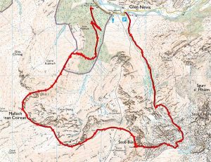
The Route
Introduction
The Walk
I found out during the week that a friend, Kevin, was looking for walkers to accompany him on a trip to the Mamores on Saturday. As this was a good opportunity for me to walk with a more experienced walker I gave kevin a ring and a decision was made to walk the “Ring of Steall”, a group of four Munro’s due South of Ben Nevis. We arranged to meet at the car park at Aichriabhach at 0830 in the morning on Saturday 20th June so it was an early start for both of us. After a restless sleep I was up at 0500 and after a quick breakfast I was on the road by 0530 arriving at the car park by 0800. Kevin turned up as arranged at 0830. The rain was drizzling down and there was low cloud and mist on all the hills. The weather forecast was pretty accurate at this point apart from the wind, there wasn’t any and the midges were looking for breakfast lol. The “Ring of Steall” is a walk that needs to be viewed and enjoyed in all its glory but due to the heavy mist that was not looking so good. The weather was due to improve with sunshine in the late afternoon but we wanted to be away by then so we decided to walk the two Western Mamore Munro’s, Mullach nan Coirean and Stob Ban instead. Neither of us had done these two before so it made good sense.
So by 0845 approximately we walked back up the road for about 100 metres then headed into the forest following the forest track. Now I normally prepare a gpx track for the route so I have a good idea of the appropriate route to take but because of the change of plan I didn’t have that luxury. Also I had a little hickup with my gps device so we had walked about 500 metres before I got a signal. I had a printout of the “Ring of Steall” map but that did not come over as far as the forest so I was relying on Kevin for this part of the route.
The path zigzags through the forest and the path we took came to an end at a stream whereby we then had to head west vertically through the dense forest and then continue upwards through the bracken. This was damn hard and physically demanding for me anyway. (I think most walkers would continue on the track to the North West for a further 1km before headed South West up Sron Riabhach ridge. This would be the obvious route to take on reflection) However we struggled up the near vertical slope and arrived at the path at the 600 metres contour. I was about 50 metres behind Kevin at this point looking for the oxygen tanks by now. That path up through the forest was approximately 330 metres vertical over 500 metres horizontal so it was a steep ascent in anyones book. However we are now on the main stalker/walkers path getting our breath back and looking forward to the rest of the walk.
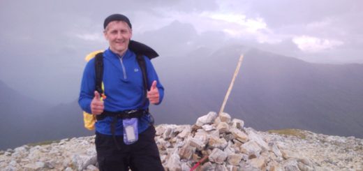
It’s now a simple ridge walk up to the first Munro with a curving track of about 1.5km. The mist was still thick and we couldn’t see any of the wonderful views that these mountain ranges offer. Also there is a small cairn on a summit 200 metres from Mullach nan Coirean which, due to the mist, could make the walker think they are on the summit. However when you actually arrive at the Munro summit it has the biggest cairn I have ever seen and it can’t be mistaken.
We stop for a bite to eat and take a picture or two. It’s now 1057 and it has taken us approximately 2 hours to get here. After about 15 minutes we are heading on our way again along the well-trodden path. Basically the path from here takes you all the way to the summit of Stob Ban. The mist rolls out and back in again and gives us glimpses of the spectacular views. Great drops to our left, Ben Nevis with its head in the clouds to the north, Aonach Eagach to the south and the “Ring of Steall” and Devils Ridge to the East. After about a kilometre we arrive at a cairn at 917 metres.
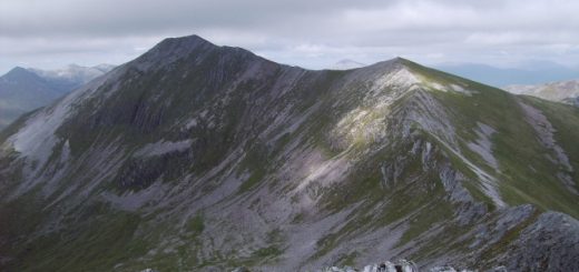
Looking across the the east you can see Stob ban and it looks impressive. This huge cone shaped quartz mountain looks fantastic from here. It’s now 1.5km downhill then 0.5km along and then the last 0.5km up to the summit. This is a nice climb and is steep but before we know it we are at the cairn on the summit. Again the mist prevents us from seeing anything. The time is now 1215 and we have a quick photo and food stop. Now from here walkers can continue on and walk devils ridge and Sgurr a Mhaim but because of the mist we decide to call it a day and head back to the car.
After a quick discussion Kevin spots a path on the map going down the hillside between Coire nam Miseach and Coire Mhusgain and that is the route we decide to take. It’s a 1km walk downhill and you turn sharp left down the path into the Coire just before the Lochan. Using my wonderful gps I walk past the turn off and Kev shouts me back lol. (I would have noticed in a pace or two honest). So we head down through the Coire. Its steep and boulder strewn so great care is required. From here we basically walk/run the 4km back to the car but I have to say it’s a stony uncomfortable path and with soft soles on my boots it’s not much fun..
All in all a great day in the hills with great company.