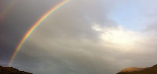
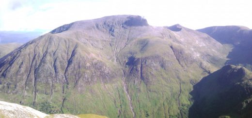
The Eastern Mamores

DIGITAL IMAGE
Statistics
Area: Fort William to Loch Treig and Loch Leven
Munros: Binnein Beag, Binnein Mor, Na Gruagaichean, Sgurr Eilde Mor
Date walked: 27/06/2009
Time taken: 9 hours
Distance: 17 km
Ascent: 1760m
The Route
Introduction
The Mamores are a range of hills and peaks lying between Fort William and Kinlichleven containing Ten Munro’s. There are a number of routes available with some walkers walking all Ten Munro’s in one day. This walk covers the Four Munro’s at the Eastern edge of the range.
The Walk
“The best laid schemes o’ mice an’ men Gang aft a-gley, An’ lea’e us nought but grief an’ pain, For promised joy” Robert Burns (1759-1796)
And so it came to pass that I had a plan. I am a fit young man (lol) so maybe I can walk 8 Munro’s in the Mamores. I walked two last week with Kevin and felt like doing something more adventurous. I would take camping gear with me and camp out overnight and hopefully do 4 and 4, or 5 and 3 or….. you get the picture. The good news was that I had a job in Inverness on the Friday which should finish about midday meaning I could get to my start point in Fort William at the car park at Polldubh in Glen Nevis for about 1400. So on Thursday night I loaded all my gear into the car and on Friday morning I set off early for Inverness. However after I finish my work in Inverness my boss asks me to go to a job in Aberdeen. Damn it this was not my plan. In fact it was a major setback and I was now thinking that I might not get across to Fort William today and the walk would have to be postponed. It’s almost a 3 hour drive from Inverness to Aberdeen, in the wrong direction to Fort William may I add, so I am going to have to drive back across to Inverness then onwards for another 1.5 hours to Fort William if the walk is to go ahead.
So over to Aberdeen I go, then after completing what was a simple job, I drive back over to Inverness and on to Fort William. I have now been driving today for almost 11 hours and its now 2000 (8pm). I had hoped to be at Coire an Lochain below Sgurr Eilde Mor by now after bagging 2 munros (the two biggest climbs) and now setting up camp. That would have left 6 Munros for the Saturday but unfortunately I way behind schedule am only now setting off on my walk. On reflection it would have made sense to sleep in the car but isn’t hindsight such a wonderful thing.
My new plan is to walk the first 8 km along past the falls of Steall and camp out overnight, then start walking at first light crossing the Water of Nevis and heading directly up Binnein Beag. So I pick my pack up and nearly die lol. I think it weighs about 45lb. I certainly do not have any of the new-fangled lightweight gear that walkers buy nowadays and my tent and sleeping bag are relatively heavy. Not to mention all the food and water I am carrying. Hey but it’s not going to kill me right lol.
So I am now on my way.
The roadway to the second car park looks good but I decide to take what looks like a good track south of the “Water of Nevis” that runs adjacent to it. There are some clouds in the sky but it is warm being mid-June and there are a few midges flying around. Now the pathway looks good but after about 1.5km the path gets thinner and large ferns are growing wildly intruding onto the pathway. As I continue just South of the burn, the path start meandering slightly up and down getting bumpier and smaller before ascending into a small copse/treeline where I have to cross a small fence.
Maybe I missed a turn to the bridge over the “Water of Nevis”, clearly marked on the map, because I find myself 20ft above the river with cliffs in front with the only route being a climb going upwards. This is not good especially with a large pack on my back. I am above the Burn just before it takes a sharp 90 degrees bend South East heading along the Gorge. The burn is about 20ft across but it isn’t very deep today with the river bedrock comprising of huge boulders beautifully carved with intricate curves and colours by centuries of water flowing in fits and torrents. I could always walk back to the car park and use the bridge but I can see the path on the other side of the river so I decide to descend and climb across the boulders.
Without further ado I am on the other side and walking on the path into Glen Nevis. That was scary. I do not recommend the route on the south side of the river. Please walk along the road on the North side of the river and then onto the good track. The path through the Gorge into Glen Nevis is tremendous and imparts a Jurassic park type feeling every time I visit. It narrows as you descend into the Glen then Opens out into Glen Nevis with the picturesque An Steall waterfall to the South. I continue along the path, passing the steel wire bridge and walk another 3km along the path looking for a suitable area to pitch my tent ready for a good night’s sleep.
Unfortunately it’s now getting dark and I can’t find what I would consider to be a good pitch so I make do with pitching just at the side of the path. Sometimes you just have to make do and after some long awaited dinner I was comfortable enough and counting sheep ready to nod off. I woke a few times during the night with the wind and the rain doing their best to keep me awake. The weather forecast was for sunshine but at 8am it was still raining. By 0900 the rain had stopped so I crawled out of my pit had breakfast and packed my gear ready for the hills.
So after a later start than I expected at 1000 I am walking. Binnein Beag has its head in the mist and there doesn’t appear to be a path going up the hillside so I again cross the “Water of Nevis” and head on upwards through the heather. I spot a couple of walkers high above me so at least there is company on the hill. After a period of hard walking steeply ascending the hillside I catch up with my fellow walkers. They are a Granddad and Grandson doing some camping and walking in Glen Nevis.
We have a quick chat and I am again on my way going straight up heading for the summit. I cross a path and head directly up the steep boulder field on all fours. After crossing a patch of vegetation and then another boulder field on all fours again, (reminds me of the final ascent up the boulder slope on Ben Nevis), I am now on the final short climb to the summit and thinking that the ascent was a bit tougher than I had imagined. The summit is still in the mist and the time now is 1130.
I now head off down the path to the South side of the Lochan. I take this opportunity to refill my water bottles and I use Chlorine tablets to kill the germs. It’s now a 2km walk along a path skirting the lower slopes of Binnien Mor 500m below the summit to Coire an Lochain. I was planning at this point to head straight up to the summit of Sgurr Eilde Mor but notice the path heading north and traversing around the side so I decide to take the path.
After a short while the path gets steeper and steeper until, near the top it is steep scree and it’s difficult to keep my footing. There are a couple descending and I stand aside to let them pass and with a little bit of care I am soon at the summit. The time is now 1315. Again I am in the mist but at least it’s warm. I now retrace my route back down the path to the Lochan and refill one water bottle, the contents of which I have just drank, and continue on my way.
The path heads up to the North of Sgor Eilde Beag. I notice a group of walkers up ahead and after a short time I am only 50 metres behind them. About 5 metres below the Beag they decide to climb vertically up the cliff instead of following the path. All of a sudden there is a roaring thumping and a huge boulder passes me to the left. I didn’t have any time to react and there were no cries of “Below” (the usual warning to shout if you dislodge a rock whilst walking/climbing) so I was lucky that the boulder missed me. If I had been in its path it would have made quite a mess of me I am sure.
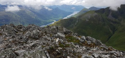
I quickly get to the top of the Beag and one of the group apologise for dislodging the rock. It’s now 1415 and I take 10 minutes out for some photos. The mist is clearing and I can see some excellent views South over Blackwater resevoir and Loch leven, with the Aonach Eagach standing proudly on the skyline.
It’s now an ascent of 500m to the spot height at 1062. The group have dropped their bags and are heading off to the summit of Binnein Mor. I drop my pack and head of after them. It’s a relief to lose the weight from my back and I quickly jog to the summit of Binnein Mor. One of the walkers kindly takes a photo of me and I now head back to my backpack. I am pleased with myself at this point. 10km and 3 Munros in 5 hours. Now my next Munro is Na Gruagaichean which is only 1km away and only takes 20 minutes. The time is now 1520 and I rest for 20 minutes whilst I have some lunch and water/isotonic drinks. I stand up and look across at Am Bodach and Stob Coire a Chairn with a great big valley in between and for the first time in my life I get Vertigo. I can’t believe it. It all looks so immense. I get a grip of myself and look over the edge.
My plan is to go over the edge and down the steep boulder slope to the pathway on the North West side of the hill. I could see a path heading directly North but it just didn’t register that that really was the way I should go lol. That path (the one normal walkers would chose to take) heads North for 200m over the spot height then North West down to the Beallach and ascends to Stob Coire a’Chairn. However I was doing this “My Way” and undaunted by the immensity of it all I head directly West from the summit down the steep boulder/scree/grass slope descending 300m and arrive at the planned intersection with the path at 1600. So far I have been going well. No problems, no cramp, in fact it’s been a great day and I have already bagged 4 Munros.
Now it all goes wrong. Suddenly I feel tired. The path heads upwards and after a kilometre or so I come across a small cairn. I remember wondering what the cairn was for lol not realising that it indicates the path I had planned to take. I had planned to take this path from the cairn and go around the hillside to Bealach at 857m and continue over it to take the path, (marked on the map but which I found no longer existed on the ground), along the hillside behind An Gharbhanach.
However my senses are muddled and I continue on the path to Stob Coire a’Chairn. I walk another 500 metres and stop. I look up at An Gharbhanach and Stob Coire a Chairn and realise that I have missed the path. I am only 80 metres in height below Stob Coire a Chairn but I don’t really want to climb this one and An Gearanach twice. I glance across at Am Bodach with fear hahahah. Gee whiz will you take a look at that climb. Its then that I decide I will not be adding the “Ring of Steall” today. I am tired. The weight on my back is wearing me down. I now feel a sense of disappointment.
I turn around and head of back down to the cairn. I take the fork off the main track and follow it all the way to the bealach. I have to climb 50 metres so with hind sight I should have continued to the top of Stob Coire a Chairn. I feel stupid. I cross the Bealach and head down the path on the other side looking for the path marked on the map that should traverse the West face below An Garbhanach and An Gearanach. After a short while the path should be going to the right behind the hill but it’s not.
This is a stalkers path which descends the hillside into the Allt Coire Mhail which is not where I want to be heading. I crisscross along the hill ascending and descending trying to find the path but it’s nowhere to be seen. The ground under foot is boulder field/scree/grass, very steep and not very comfortable. I use my gps but still can’t find the path. I descend to approximately 650 metres. After consulting my map I realise that I have to go back up to 920 metres to find the path back to Steall.
I am absolutely knackered now but I have no choice but to climb back up the hillside. The hillside feels almost vertical and should only be the preserve of mountain goats but I persevere. I do believe that without my trusty walking poles I would never have been able to do this climb. It’s seriously physically hard.
It takes me 50 minutes to climb 200 metres and was mentally and physically draining. I am relieved to eventually reach the spot height below An Gearanach. The summit is only 60 metres higher but I am well past my sell by date by now. The “Ring of Steall” will have to wait for another day because words just can’t explain just how knackered I was and I know that today has totally wiped me out. The logical move would have been to camp for the night below An Gearanach but I wasn’t thinking logically.
My brain was telling me I need to get of this mountain so down I go descending on the zigzag track down to Steall and I arrive at the waterfall at 1910. I pitch my tent, have a quick wash in the river, change my clothes and I get into my sleeping bag. It’s only a three mile walk to the car but I have had enough and I will walk out on Sunday morning. After lying down for 30 minutes or so I am sick a number of times. I think it was due to physical exhaustion and this has happened on a number of occasions in the hills since.
Footnote:
My walk (I did it my way lol) was very hard. Had I continued up Stob Coire a Chairn and walked up An Gharbhanach and An Gearanach 1 would have saved myself about 200 metres of very hard climbing and bagged two more Munros into the bargain. It’s small consolation to me that I can bag them when I walk the “Ring of Steall”. My problems with cramp seem to have completely disappeared most probably due to the salt laced isotonic drinks. It was not the best decision I have ever made to go off the West face of Na Gruagaichean. Using Chlorine tablets and local water supplies was a master stroke because I drank 5 and a half litres of fluid during this walk which would have increased the weight in my backpack should I have had to carry all that water. (I rarely needed to go to the toilet so all that fluid was coming out my pores.) And the sickness at the end was due to exhaustion. Great fun eh lol.