Six Munro’s East of Glenshee
Statistics
Area: Braemar to Montrose
Munro’s: Cairn of Claise, Carn an Tuirc, Creag Leacach, Glas Maol, Tolmount, Tom Buidhe
Date walked: 10/10/2009
Walk time = 5hrs 50 mins
Bike time = 30 mins
Total time = 6hrs 20 mins
Distance= 27.1km
Ascent: 2150m
The Route
Introduction
Six Munro’s East of Glenshee. The Glenshee Ski centre sits just off the A93 14km South of Braemar at a height above sea level of almost 650m. A large number of Munro’s in the Southern Cairngorms can be accessed from this high pass. On this occasion I chose to walk the 6 Munro’s to the East of the A93. The start point is 3km North of the Ski centre at a height of about 500m so there is a relatively short climb to the first Munro.
The Walk
I drove up to Glenshee on Friday night in preparation for walking 6 Munros to the East of Glenshee starting on Saturday morning. The plan was to drop the bike off at one of the car parks just off the A93, park at the other car park 5km along the road, do the walk from the van and cycle back to the van. Now both car parks are at the bottom of a hill (either end of Glenshee) with a distance of 5km between them so whichever way I do the walk I will have a steep hill to ascend on the final road section.
The South car park is at the bottom of the hill on the right as you drive to Glenshee from Blairgowrie and the North car park 5km further North past the Glenshee Ski centre on the right hand side of the road between some black and white barriers. The way I had arranged the walk I would have to cycle/push the bike up a 2km hill from the South car park and cycle downhill for the final 3km’s but I didn’t fancy an additional 5km road walk tagged on to the end of this walk so this was how it had to be.
Also due to the fact That I am going into the middle of nowhere It’s big pack time with my tent, slippers, bathrobe and clean underwear in case I get run over lol.
Well, after another broken night’s sleep, what with the wind and the rain and the deer and other nocturnal creatures making strange noises I was up and raring to go. I had retired for the evening parked up at the South car park and my first task was to drop the bike onto the heather over the edge of the car park. This would keep it hidden from the car park and the road and I then drove up the hill and down past the Ski centre to the North car park. I actually parked the van on the left of the A93 approximately 50m past the main parking area for reasons only known to myself lol..
It was now 0825 and I was on my way. A group of 6 guys had set of 5 minutes before me and I could see them disappearing over the rise. The summit of the first Munro was in the mist so I took a couple of pictures before setting off. There is a clear track which I followed from the car park but after only a short time the boggy ground seems to devour it and I found myself following a stalkers track up the nearest hillside. Realising my error I was soon back on the correct track and heading off into the heather.
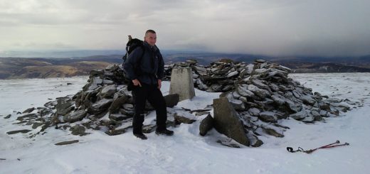
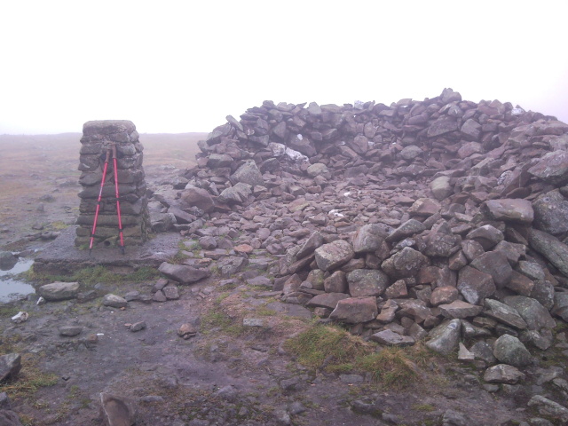
The path follows the burn for the first km and then crosses a tributary and starts to head uphill. At this point there is only 300m of ascent to climb to the summit of Carn an Tuic over 1.5km distance. I could see the guys ahead of me and I was catching them up. When I got to about 900m I caught them up and continued on my way. My gps was telling me the summit was pretty much directly East but the main path bends to the South East at this point and the guys were heading off in that direction. I shouted to tell them that the summit was up above me and they altered direction heading across the heather towards me. I was working hard and after entering a short boulder field I arrived at the summit. I was in the mist again with nothing to see so after quick photo I was again on my way.
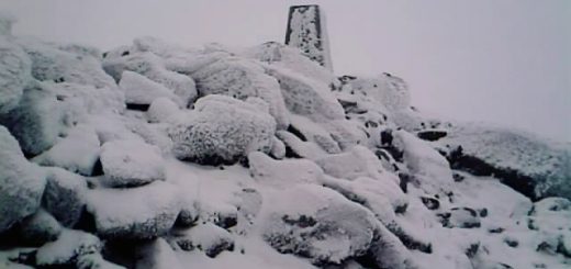
I now head East for 500m to circuit the top of Coire Riabach then South East for 500m then pretty much South for 1km to the summit of Carn a Claise. As I near the summit I meet a boundary which runs along to the summit. The terrain is pretty much boulder field everywhere at this point and I am still in thick mist but I decide to bag Tolmount and Tom Buidhe nonetheless.
I leave the cairn and head North East for 300m to pick up a path heading East. I follow the path for about 1km and then I head directly across the moorland North East for the final 1km or so to summit of Tolmount. I do find a path occasionally but it comes and goes and I cross a vehicle track heading to Tom Buidhe but I am not going that way just yet. The moorland is very boggy with it being so flat and I traverse the bog as best I and I soon find a small path climbing to Tolmount. I arrive at the summit at 1040 still in the mist and without further ado I head off to Tom Buidhe. It’s basically an easy walk across the heather down to the Bealach and then up to the summit, a distance of only 1.5km. The time is now 11:10 and I now head back to Carn a Claise
Now the good thing is that there is vehicle tracks from Tom Buidhe all the way to Carn a Claise so even though it’s boggy I can make good progress and by 1145 I am back at Carn a Claise for a second time.
My next munro is the highest on the round, Glas Maol. I head South West from Carn a Claise for 2km remembering to skirt around the corries of Garbh Choire. Although I am still all in the mist I don’t feel any danger at all. I pick up a vehicle track again heading South. I passed the ski lift and after 500m left the track and headed of into the hillside to climb up to the summit. I hadn’t seen anyone since the first summit but the summit of Glas maol was very busy. A couple were in the cairn and left as I arrived. Two more couples came up separately and a group of maybe 10 people appeared all within minutes of each other. I changed my battery replenished with food and headed for the last Munro, Creag Leacach.
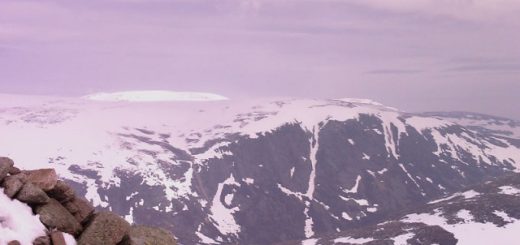
From Glas Maol I walked South West then South for 700m to the Beallach where there is a clear path which goes all the way to the summit of Creag Leacach. The sun shone through for the first time so I took the opportunity to take a couple of pictures. It’s an easy climb up to the rocky summit and then over the top and onwards to the next spot height at 943m.
I head North East from here to pick up a path which takes me Down Meall Gorm to the burn. I cross the burn and follow the path all the way back to the South car park. Now due to erosion this path is almost in the river for most of the way and because of the boggy conditions I found it very uncomfortable.
I was now back at the South car park at 1415. However my ordeal is not over. I get on the bike in lowest gear and try to cycle the 2km up the hill and its murder. So I had to push the bike all the way up the hill which took 25mins and then free wheel all the way back to the car. That climb wiped me out. A good days walking over some pretty easy hills but tiring nonetheless.